Daijiworld Media Network – Houston
Houston, Sep 2: Former Tropical Storm Edouard weakened into a depression on Tuesday night after bringing heavy rain and strong winds to parts of Texas, leaving thousands without power, uprooting trees and flooding roads.
The storm weakened several hours after making landfall near the Texas-Louisiana border with maximum sustained winds of around 60 mph, according to the National Hurricane Center.
Forecasters said Edouard would continue to lose strength as it moved inland but warned that heavy rain and possible flooding could persist into Wednesday.
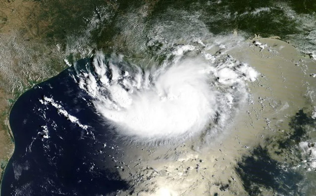
The hurricane centre forecast rainfall totals of 3 to 7 inches, with isolated areas potentially receiving up to 12 inches.
As the storm moved over Beaumont, Texas, around 80 miles northeast of Houston, city offices were closed and the Texas Office of Emergency Management urged residents to avoid travelling unless necessary.
Beaumont Police reported fallen trees blocking roads, malfunctioning traffic signals and flooded underpasses across the city.
Around 32,000 electricity customers in Jefferson County, which includes Beaumont, were without power, according to power outage tracking data.
Along Texas’ Crystal Beach, surf shop owner Mike Gilbert had decided to close his business ahead of the storm to avoid difficulties for employees travelling home. However, the area experienced mostly cloudy skies and light rain as Edouard made landfall around 60 miles northeast.
In Cameron, Louisiana, winds increased and intermittent rain affected the coastal community. Local RV park owner Connor Salvador said some flooding was possible if rainfall increased but added that residents were accustomed to storms in the area.
Meanwhile, several tropical systems were active over the Pacific Ocean.
Hurricane Lowell was expected to remain several hundred miles away from Hawaii over the coming days, although swells generated by the storm could affect parts of the islands from Wednesday. The National Hurricane Center warned of dangerous surf and marine conditions for beachgoers and boaters.
Tropical Storm Marie formed early Tuesday over the Pacific, well offshore from southwestern Mexico. Forecasters expected Marie to strengthen into a hurricane by Wednesday night, with swells likely to affect parts of the southwestern Mexican coast and the Baja California peninsula.
Another storm, Karina, strengthened into a Category 4 hurricane on Monday after becoming a hurricane on Sunday over warm waters far from land. Forecasters said Karina was expected to weaken.
The combination of active systems in the Atlantic and Pacific highlights a busy period of tropical weather, with authorities continuing to monitor the storms for potential impacts on coastal and inland communities.