Daijiworld Media Network - Sriharikota
Sriharikota, Jul 30: In a historic leap for space collaboration between India and the United States, the jointly developed NASA-ISRO Synthetic Aperture Radar (NISAR) satellite was successfully launched on Thursday evening.
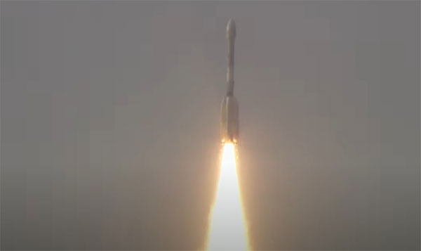
Blasting off at 5:40 PM IST aboard India’s GSLV-F16 rocket from the Satish Dhawan Space Centre in Andhra Pradesh, the launch marked the Geosynchronous Satellite Launch Vehicle's first-ever mission to a sun-synchronous orbit — placing the NISAR satellite at an altitude of 743 km.
The Indian Space Research Organisation (ISRO) celebrated the milestone on X, posting, “We have liftoff! GSLV-F16 has successfully launched with NISAR onboard.” Minister of State for Science and Technology, Dr. Jitendra Singh, also hailed the launch, calling it a new chapter in space diplomacy.
The $1.5 billion mission is the first Earth observation venture jointly developed by NASA and ISRO, designed to deliver high-resolution, round-the-clock imagery of Earth’s land and ice surfaces. Using dual-frequency synthetic aperture radars — NASA's L-band and ISRO’s S-band — mounted on a 12-meter deployable mesh antenna, NISAR will track environmental changes with unprecedented accuracy.
“Go NISAR!” NASA declared after liftoff, emphasising the satellite’s role in monitoring dynamic processes like landslides, glacier movements, soil moisture, and tectonic shifts — crucial for disaster prediction and climate research.
ISRO Chairman Dr. V Narayanan explained that the satellite would generate data regardless of weather or lighting conditions, scanning the planet every 12 days across a 242-kilometre swath using cutting-edge SweepSAR technology.
NASA supplied key components including the L-band radar, a high-speed telecommunication system, GPS receivers, and the massive antenna. ISRO built the satellite’s S-band radar, launch vehicle, and provided all ground support services.
Weighing over 2,390 kg, NISAR’s capabilities extend to tracking sea ice changes, monitoring shorelines, detecting ships, mapping crops, and studying storm development. It is also equipped to detect millimetre-level movements in Earth’s crust — data essential for understanding natural hazards like earthquakes, tsunamis, and volcanoes.
Beyond its scientific mission, NISAR represents a deepening strategic partnership between India and the United States in civil space cooperation, underlined by recent bilateral agreements and upcoming initiatives in 2025.
As the satellite begins its journey in orbit, both agencies look forward to unlocking new insights into Earth’s changing systems — a shared vision powered by science and collaboration.