Daijiworld Media Network – New Delhi
New Delhi, Jun 28: Large parts of India remain under unusually cloud-free skies, with the latest satellite imagery revealing a striking absence of widespread rain-bearing clouds over central, western, and northwestern India. However, after a sluggish phase, subtle signs of a monsoon recovery are beginning to take shape.
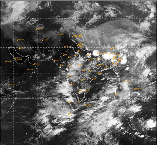
The latest INSAT-3DR infrared satellite images paint an unusual picture for late June. While dense cloud bands are concentrated over the northeastern states, the northern Bay of Bengal, and parts of the southern peninsula, vast stretches of Maharashtra, Madhya Pradesh, Gujarat, Rajasthan, Uttar Pradesh, and Delhi-NCR appear largely devoid of the deep convective clouds typically associated with an active monsoon.
The sluggish progress left the country with a massive rainfall deficit earlier this month. The India Meteorological Department (IMD) noted widespread shortages across central and northern India. Madhya Pradesh and Gujarat remained among the worst-affected states, reporting significant deficits alongside Uttar Pradesh, Bihar, Karnataka, and Kerala.
Meteorologists link the weak cloud cover to the absence of strong monsoon systems over the Bay of Bengal and the Arabian Sea. Without low-pressure areas travelling inland, moisture transport has remained limited, suppressing widespread rainfall over much of the country's interior.
However, weather models indicate that this dry lull may finally be nearing its end. A large tropical weather system is currently developing north of the equator over the eastern Indian Ocean. Forecasts suggest it could move northwards into the Bay of Bengal over the coming days.
As the system gathers strength, it is expected to pump abundant tropical moisture into the monsoon circulation, providing the necessary ingredients for a fresh burst of rainfall. The strengthening moisture flow is also expected to create favourable conditions for the formation of a monsoon low-pressure area over the Bay of Bengal.
Simultaneously, atmospheric models indicate the possible development of a middle-tropospheric vortex over western India, a weather feature often associated with enhanced rainfall over Maharashtra, Gujarat, and adjoining regions.
If these systems develop as projected, they could help restart the stalled monsoon and accelerate its advance into the remaining parts of northwest India by the first week of July, bringing much-needed relief to the parched regions.